Cartographic Futuremaking: Articulating the design space of “peace cartography” in Bosnia and Herzegovina and its effects on landscape futures
Dr. Mela Žuljević, IfL
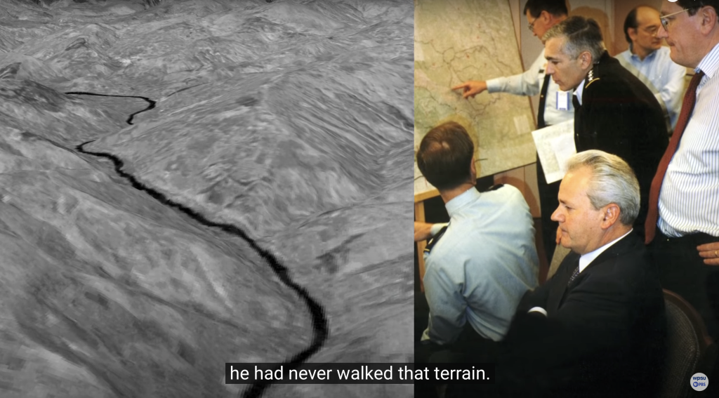
Screenshot taken from the WPSU‘s Geospatial Revolution series, Episode 3, on the use of the Powerscene technology in drawing the division line in Bosnia-Herzegovina during the Dayton peace agreement talks (Copyright: WPSU and Geospatial Revolution. Screenshot used with permission).
Project description
In the fall of 1995, peace was brokered between different parties involved in the war in Bosnia and Herzegovina, with the help of international diplomacy in the city of Dayton, Ohio. During the peace talks, a division line was drawn between two entities, the Federation of Bosnia and Herzegovina and the Republic of Srpska. This ‘peace cartography’, guided by international expertise, was presented as a neutral and objective process – however, it not only solidified ethnic divisions but also introduced neoliberal and neo-colonial mechanisms in handling them. This project is interested in tracing the consequences and afterlives of this cartography – by exploring how they were inscribed in the post-war development of landscapes in Bosnia and Herzegovina. Through design research on particular landscapes in which the division line was drawn, the project will make legible how their future was shaped by peacebuilding visions. By creating an atlas of technologies, things and practices involved in drawing the line, it will explore how these visions were staged as ‘progressive’ and ‘benevolent’ through cartographic design. The research starts with a systematic analysis of maps and visualisations produced in the context of conflict and peacebuilding in ex-Yugoslavia, focusing on the territory of Bosnia and Herzegovina. It continues by engaging with specific case studies of post-war landscapes through fieldwork, design research and atlas-making. Finally, the research insights will inform the design of visualisation methods and tools which can support a critical and situated approach to visualising the complexities of landscapes in peace and conflict contexts.
Key questions
Methodology and sources
Project team
Dr. Mela Žuljević
Related publications

ARTICLE: Design Space in Cartography: Outlining a Design Perspective in Critical Analysis of Peace and Conflict Visualisations
Author: Mela Žuljević (IfL)
In: Abstr. Int. Cartogr. Assoc., 6, 294, 2023
Published online: 12 August 2023
ARTICLE: Post-reconstruction enclosures: an infrastructural perspective on the post-conflict landscape of the Old City (Mostar)
Authors: G. Carabelli, Mela Žuljević (IfL)
In: Landscape Research 2023
Published online: 26 Jul 2023